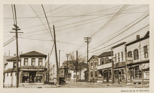
Wires crisscrossing on Brown Street, at Warren Street, looking north. (Photos Courtesy of University Libraries Special Collections and Archives)
By Jane Wildermuth, Head of University Libraries Special Collections and Archives
Lisa Rickey ’05, ’08, Archivist and Collection Manager, University Libraries Special Collections and Archives
“Mr. Watson, come here. I want to see you.”—Alexander Graham Bell
In March 1876, the United States Patent Office granted Alexander Graham Bell patent number 174465A for a method of transmitting speech by telegraphy—the telephone. Two years later, Bell’s invention made its way to Dayton, with little regulation to control or guide its implementation.
In 1879, over a span of months, multiple companies—National Bell Telephone Exchange, Western Union Telephone Co., Bell Telephone Exchange, and Edison Telephone Co.—erected a haphazard patchwork of poles and lines.
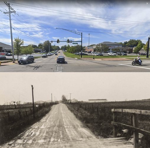
Whipp Road at Lebanon Pike (Far Hills Avenue), looking west, shown in Google Maps today (top) and in 1923.
By 1923, following phone company consolidations, the Ohio Bell Telephone Company was the area’s only telephone provider. It notified the Public Utilities Commission of Ohio (PUCO) of substantial rate increases.
The City of Dayton objected, filed a complaint with PUCO, and hired electrical engineer Elijah Ellsworth Brownell to serve as an expert witness and to secure data on how Ohio Bell arrived at the valuation figures used to justify the rate increase.
In an article that appeared in the Dayton Daily News on March 4, 1923, Brownell wrote, “We have hundreds of miles of duplicate duct feet of conduit, and hundreds of miles of poles of duplicate pole lines upon our streets, and many hundreds of miles of duplicate aerial lead-sheath cover telephone cables and open wires.” He goes on to say, “We are wondering who is to pay for this evil and if the innocent telephone subscriber will again be called upon to assume the losses.”
In March 1923, Brownell compiled a book of 113 photographs documenting the locations of telephone poles and lines in Dayton and rural Montgomery County. Presumably, Brownell’s photographs were used to further the city’s effort to prevent the rate increases.
One hundred years later, the photographs serve a different purpose. They provide snapshots in time, often depicting major road intersections and the surrounding land and buildings.
Some of the scenes look familiar, such as Photo No. 10, on South Brown Street, just south of Fifth, looking north (shown below in a mashup with a Google Maps image, under Fair Use).
And some of the scenes look quite different—as one might expect from nearly 100 years of change—such as the scene in Photo No. 80, Whipp Road at Lebanon Pike (Far Hills Avenue), looking west.
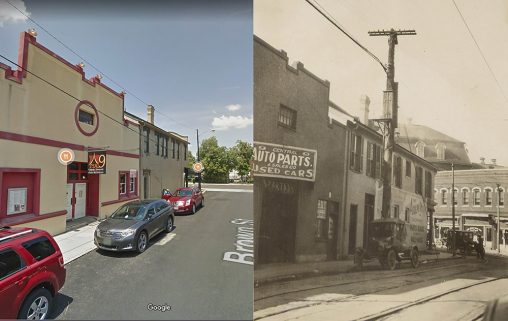
South Brown Street, just south of Fifth Street, looking north, shown in Google Maps today (left) and in 1923.
View the collection online at CORE Scholar at corescholar.libraries.wright.edu, Wright State University’s institutional repository. All images in the online gallery have been geo-tagged with the exact location the photo was taken.
For more information on the collections in the University Libraries Special Collections and Archives, visit libraries.wright.edu/special.
This article was originally published in the spring 2023 issue of the Wright State Magazine. Read more stories at wright.edu/magazine.
 Wright State’s Raider Immersion Program connects students to paid defense and industry learning opportunities
  Wright State University Foundation funds 11 projects to enhance student success
  A passion for storytelling
  Wright State student Chloe Detty appointed by governor to serve as student trustee
  Wright State inspires the next generation of business leaders through Ohio Business Week